
Draw three contours through a triangle of spot levels
Plot a surveyed triangle, interpolate two crossings for each contour and use an elevation equation to check the resulting segments.
On this page
Station sheetFind the first two contoursHandle a contour above station CCheck the map without reusing the edge fractionsA level book gives you three elevations. A contour map asks for lines joining locations of equal elevation. Between those observations you must make an assumption about the ground. In this exercise the three stations form one flat triangular facet, so elevation changes linearly along every straight line within the triangle. Your job is to draw the 102, 104 and 105 m contours and show why each line ends where it does.
Station sheet
| Station | Easting (m) | Northing (m) | Elevation (m) |
|---|---|---|---|
| A | 0 | 0 | 101.2 |
| B | 40 | 0 | 105.2 |
| C | 0 | 30 | 104.2 |
Draw north upward and east to the right using the same scale on both axes. Join A to B to C to A. Leave room alongside each edge for two sets of numbers: the elevation difference between its endpoints and the fraction of the edge needed to reach a target elevation. Before reading the solution, predict which of the three contours can cross edge BC. This prediction catches most of the drawing errors in the exercise.
Find the first two contours
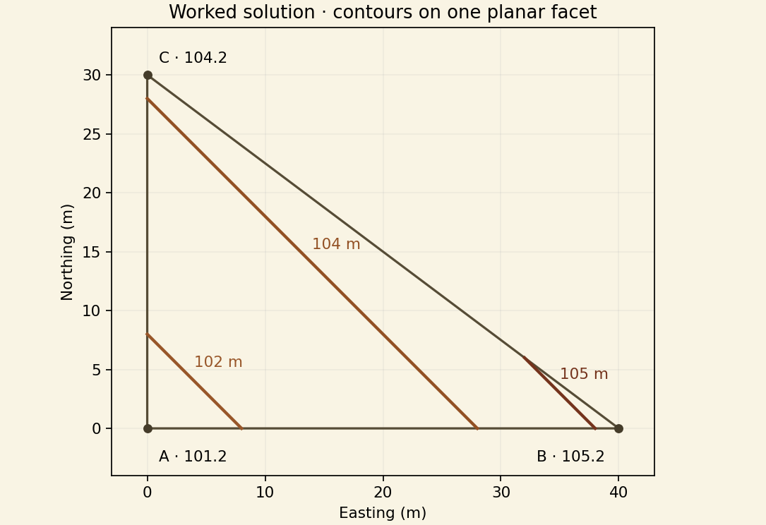
Along AB the elevation rises 4.0 m over 40 m horizontally. Starting at A, the rise needed for the 102 m contour is 0.8 m. The fraction is 0.8/4.0 = 0.20, giving a crossing 8 m from A at E 8, N 0. Along AC the total rise is 3.0 m over 30 m. Reaching 102 m takes 0.8/3.0 of that edge, again 8 m from A. Mark E 0, N 8 and join it to the AB mark.
Repeat for 104 m. The required rise from A is 2.8 m. On AB, 2.8/4.0 × 40 = 28 m. On AC, 2.8/3.0 × 30 = 28 m. Draw the second contour from E 28, N 0 to E 0, N 28. The equal crossing distances in these two calculations come from the selected station elevations and lengths. Different input slopes would give different distances on the two edges.
Handle a contour above station C
Only station B exceeds 105 m. That contour must meet both edges incident to B and cannot cross AC, whose higher endpoint is only 104.2. On AB its crossing is 38 m from A. To find its BC crossing, travel from B toward C. The elevation falls 1.0 m in total and 0.2 m of fall reaches 105.0. Move one fifth of the way from B to C in plan.
The coordinate change from B to C is −40 m east and +30 m north. One fifth gives −8 m east and +6 m north. Add these to B to obtain E 32, N 6. The last contour runs from E 38, N 0 to E 32, N 6. Extending it to the north axis would carry it outside the surveyed triangle.
Check the map without reusing the edge fractions
On this facet elevation equals 101.2 + 0.1 × easting + 0.1 × northing, with the three input coordinates expressed in metres. Substitute either end of any drawn segment. Both 105 m endpoints have easting plus northing equal to 38, so both give 105.0. Every point on that straight segment has the same sum. The test confirms the height of the complete segment and gives an independent way to grade the drawing.
Award credit separately for selecting the correct edges, computing crossing positions, using consistent map scales and clipping lines to the triangle. Ask students why all three lines are parallel and why a real contour may curve between surveyed points. A planar triangular facet is a local modeling assumption. A ridge, ditch or bank within the triangle would need additional observations or breakline information to represent its shape.